This manual is integrated within app, and you can see from (?) button on details screen.
 Sunrise, Sunset
Time, Direction, Current position
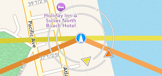
Map Area
 Orange line
Shows direction of sun rise and sun set.
 Yellow line
Shows direction of moon rise and moon set.
 Orange arrow pointer
Indicates current position of sun.
If current time is before sun rises or after sun sets, pointer is shown with dark color.
Map is moved by user operation like when slide is applied, pointer is hidden temporally. It will be shown again when tapping on map, or current location button is set to on.
 Yellow arrow pointer
Indicates current position of moon.
If current time is before moon rises or after sun sets, pointer is shown with dark color.
Map is moved by user operation like when slide is applied, pointer is hidden temporally. It will be shown again when tapping on map, or current location button is set to on.
 Blue icon
Shows user location. Arrow is pointing always north.
 Orange icon
Shows tapped location. Arrow is pointing always north.
Info Area
- Date, time, and time zone
If current location is achieved, it shows time of moment when GPS update is received. If tapped on map to show information for location, it shows time of moment when tapped.
If interested location where tapped is outside of your country or time zone, it shows time in the local time considering time zone if achieved through network.
Date can be changed from option settings menu to inquire information on specific date. When date is changed from today, red square box is shown to mark the date is not today.
Time (hour and minutes) can be changed during the day using slider shown by Time Shift button. When time is changed from current time, red square box is shown to mark the time is not current time.
- Coordinates of current location, or location where tapped on map
Display format of latitude and longitude can be changed among DMS (Degrees, Minutes, and Seconds) and decimal in option settings menu.
- Elevation (height above sea level) on current location or location where tapped on map
If interested location is in U.S., elevation data is inquired and achieved from USGS (U.S. Geological Survey).
If interested location is in Japan, elevation data is inquired and achieved from Geospatial Information Authority of Japan.
For other areas, or when network access is not available, or "Get Elevation over Network" setting is turned off, elevation is achieved from NASA SRTM (Shuttle Radar Topography Mission) data integrated within this app.
SRTM dataset is in customized form and compressed within app, so that elevation of any location world wide can be achieved, and calculation of time is more accurate. No network access is necessary with SRTM.
Posting interval of each data source of elevation is as follows:

U.S. Geological Survey, National Elevation Dataset (NED) Point Query Service: 1/3 arc-second (about 10m)

Geospatial Information Authority of Japan, Elevation API: 5m to 10m

NASA Version 3.0 SRTMGL30: 30 arc-second (about 900m)
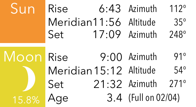
- Time of sun rise, sun set, moon rise and moon set
Calculations are made with date, latitude, longitude, and elevation of the location, by astronomic math equations.
Time zone of the interested location is considered and reflected to the calculated results of time.
Moon rise or moon set may not happen on a day. Moon rises, but moon may set on next day. Moon rise the day before, and there may be only moon set on the day. In such cases, time may not be shown, and line for moon rise or moon set is not shown.
Button Area
 Current location button
Device location is requested and shows calculated results for the location.
When tapped on map, or operations like sliding is applied, app stops following device location.
 Rotation button
When this is on, device heading is detected and map is rotated accordingly.
You can use this feature to check real world location where sun goes up, sun goes down, moon goes up, or moon goes down.
When map is rotated, arrow on blue icon or orange icon roates and points always north.
 Time Shift button
This shows slider and buttons above the info area.
Slider can be used to change time (hour and minutes) during the day, and it shows sun and moon position change according to the time. When time is changed from current time, red square box is shown to mark the time is not current time.
Right arrow button changes date to previous day. Left arrow button changes date to next day. When date is changed from current date, red square box is shown to mark the date is not current date.
Cross button resets date and time, and set it to current date and time.
 Details info button
Shows detailed information on other screen with additional information:
Address: Address of interested location. Address can be achieved through network access. Street address can be shown when available.
Azimuth: Angle from the location to sun rise, sun set, moon rise, or moon set. Azimuth of 0 degree is true north. Azimuth of 90 degree is true east. Azimuth of 180 degree is true south. Azimuth of 270 degree is true west.
Meridian: Shows time of meridian when sun or moon is in true south, 180 degree.
Altitude: Postion of sun or moon in angle at time of meridian.
Age of moon: Shows age of moon in unit of days, at the date and time. Age is not for noon, it is calculated based on time and date shown on screen.
Full moon: Shows date of full moon which is the nearest from the date. It may be passed full moon date, or coming full moon date, depending on the date.
Moon Phase: Shows phase of moon and illumination ratio at current time.
 Option settings button
Shows option settings menu, and various settings can be changed.
NOTICE: Any information shown on this app is using the best technology available, but the accuracy is not in any way guaranteed.

 日出、日入
日出、日入
 オレンジのライン